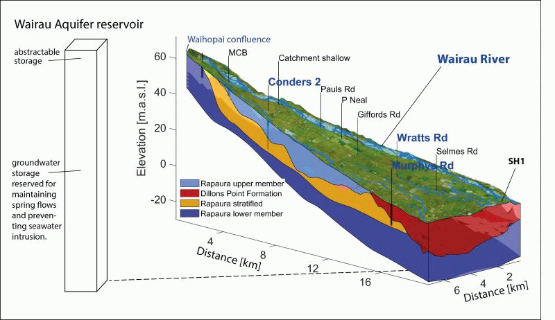
The Rapaura Formation of the Wairau Aquifer is up to 30 m thick and contains ca. 330 million m³ of groundwater. Only about 10% of that groundwater is sustainable storage that is subject to seasonal fluctuations. The majority is reserved for maintaining spring flows and for preventing seawater intrusion. Groundwater storage is estimated from groundwater levels. The annual fluctuations of sustainable storage is caused by higher river flows and aquifer recharge during the winter months and lower flows and recharge during summer (Wöhling et al. 2018). The summer lows in aquifer storage typically coincide with a higher abstraction demand.
Research articles:
Wöhling et al (2025): Comparing physics-based, conceptual and machine-learning models to predict groundwater levels by BMA.
Wöhling et al. (2020): Detecting the cause of change using uncertain data: Natural and anthropogenic factors contributing to declining groundwater levels and flows of the Wairau Plain Aquifer, New Zealand.
Wöhling & Burbery (2020): Eigenmodels to forecast groundwater levels in unconfined river-fed aquifers during flow recession.
Wöhling et al. (2018): Quantifying River-Groundwater Interactions of New Zealand's Gravel-Bed Rivers: The Wairau Plain.
Wairau Aquifer Project
AquiferWatch 2.0 predicts the current level of sustainable storage of the Wairau Aquifer using observations of groundwater levels, river flow and machine learning techniques. "Full" denotes the typical winter storage level when the aquifer is fully recharged (average of annual maximum for the years 2014-2024). "Empty" or 0 % is the storage level when one or several threshold levels from the Marlborough Environment Plan (MEP) are approached or transgressed. MEP threshold levels are set for groundwater levels and for Spring Creek flows.
In addition to the gauge that shows the current level of aquifer storage, the plot below depicts the simulated storage for the past three years, the percentiles (range) of historic storage of the past 10 years (shaded areas) and the median storage, which is a measure of the expected storage in an "average" year.
An earlier version of the model (AquiferWatch 1.0) uses Eigenmodels to predict dryweather storage up to one months ahead. Model predictions are computed for the case that no further rainfall is received in the Wairau catchment and for current levels of groundwater abstraction. They are scenario simulations for dry-weather conditions with the aim to estimate lead-times to critically low levels. For further details see Wöhling & Burbery (2020).
AquiferWatch is a joint research effort between the Marlborough District Council, Lincoln Agritech Ltd, and the Technische Universität Dresden, Germany. It was funded under the MBIE Envirolink Scheme and co-funding from TU Dresden.